Why do we measure?
To get a representative and accurate characterisation of an offshore site conditions, developers carry out on site measurement campaigns.
Investors, financial institutions, and authorities, in consonance with industry standards, assess projects' feasibility and outcomes based on the so-considered bankable data.
Bankable means reliable, trustable, transparent, reproducible, and aligned with the best practices and quality requirements set by the industry.
By bankable data, when talking about Annual Energy Production (AEP), we refer to a combination of measurements, assessment, and modelling. The same applies when talking about loads to assess project integrity, project lifetime, or design conditions for bottom-fixed foundations or floaters, for instance. In any of these examples, in situ measurements (of wind and metocean parameters) are a fundamental requirement. Despite the progress in terms of synthetic, reanalysis and availability of hindcast data, availability of measurements is a differential point when assessing the feasibility of a project. Why? Because resolution, accuracy, spatial and temporal consistency are transferred to lower uncertainty levels when assessing the outcome AEP, therefore lowering the risk of the investment significantly.
It is a fact that the industry is operating under this premise, and this is the reason why developers take measurements sooner or later along the development process; to know more about the site, to assess the conditions of the project and to provide bankable data to partners, investors and institutions which would evaluate the performance of the project, usually quite in advance that the projects become built and erected.
Measurements are somehow a message launched to the world. A project supported by measurements is not considered a desktop study work anymore, it is a proof of the seriousness and feasibility of the project. This is why in some countries, the government drives measurements as part of their centralised processes, while in other cases, developers are measuring at risk to gets a competitive advantage as fast as possible.
How do we measure?
Analogous to onshore, met masts were the available and preferred measurement station infrastructure offshore (as well) in the early days. Cup and sonic anemometers, wind vanes, temperature, and lattice structures are familiar equipment to all those related to the wind measurement world. Nevertheless, for some years now, remote device systems, like the Light Detection and Ranging Systems (LIDARS) have reverted this paradigm, mostly offshore (from the 2020’s this technology has been assumed as mainstream and standard). As always, technology provides solutions to the problems resulting from human ambitions. Once the issue of the terrain complexity, the offshore sector came along with Floating Lidar (much more cost-effective than masts). Floating Lidar Systems are those that can measure wind speed and direction at several heights (up to 300m) in any offshore location, no matter the distance to shore.

Figure 1: Floating Lidar in front of Met mast. Source: Fraunhofer
Besides the measurement technology system, the spot selection, the number of measuring assets, and the auxiliary equipment are key to defining a campaign. In addition to good execution and performance in terms of reliability and availability, the duration is also critical. In terms of temporal representativeness, at least one-year length needs to be achieved for seasonality coverage purposes.
What do we obtain from the measurements?
Assuming that the measurement campaign has been run under the accepted quality standards (according to IEC, Carbon Trust, and IEA Wind Task 32 good practices), our taken measurements are a good picture of the climatic conditions of a specific site but, and this is important, we can just be certain about this statement during the match with the period of measurement (correlation period).

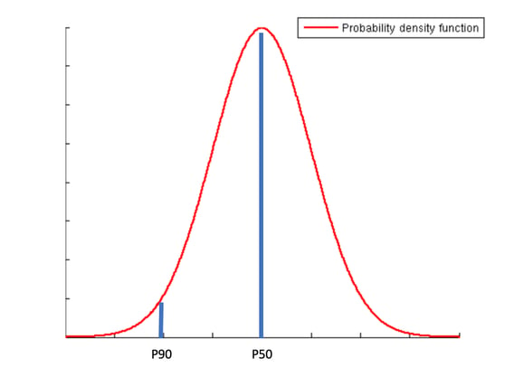
Figure 2: Example of probability distribution functions of 2 scenarios compared in Youwind
A wind farm will stand for more than 20 years, so the question is how representative the data gathered for the so-called long term (lifetime of the wind farm) we are interested in. To estimate the long-term wind resource at the site, wind modellers follow Measure- Correlate - Predict (MCP) processes. The MCP is a statistical technique used to predict the local long-term wind resource. It involves taking short-term wind speed measurements at a target site and correlating them with concurrent wind speed measurements from a nearby long-term reference (measurements from a nearby site, or reanalysis* data).

Figure 3: Time series input in Youwind
Depending on the site and the period of measurement, the taken measurements will have become more or less close to the long-term estimated values. In any way, the measurement campaign will have enlightened the interested about the variability and/or robustness of the wind resource at the site. And these are valuable learnings that will be directly transferred to the risk assessment of the investment.
And then, what?
The outcome of the complementarity between measurements and modelling might be in the form of wind probability distribution statistical parameters (i.e. Weibull Distribution Curve) or wind speed and direction time series. These data will feed wind farm simulation models (like the ones embedded in Youwind) and will yield the estimated (P50, P90, etc) AEP of the site. As mentioned in other posts, due to the wind power dependency of the wind speed (scaled at a power of 3), any statistical variation in the averaged sector wind speed will have a significant impact on the energy production and therefore in the wind farm business case.